Geography
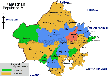
In the North West region of the country, a prominent state, Rajasthan is located. It is country’s biggest state and lies amid 69° 29' and 78° 17' E longitude and 23°30' and 30° 11' N latitude. The state is flanked by India Pakistan international border to its north west. The approximate length of this border is 1,070 km. The main cities that are flanked by this border are Ganganagar, Barmer, Jaisalmer and Bikaner. To the west of this state, Pakistan is located. In North West, Uttar Pradesh, Punjab and Haryana is situated. Gujarat is located on its southwest and Madhya Pradesh to its southeast.
The major portion of this state is dry and arid. Biggest desert of the country, the Thar Desert is located in this state. This is also referred to as “Maru-kantar”. Geographically, Aravalli Range which is oldest fold mountains chain divides this state into two zones. These two zones are desert and forest belt. About 9.36% area of this state is forest vegetation. The only hill station in this state is Mount Abu. Aravalli Range’s highest peak, Gurushikhar peak is housed in this city. The elevation of this peak is 1,772 m. Jaipur is the capital of this state.
Aravalli Range and Thar Desert are the major geographic features seen in Rajasthan. Aravalli Range crisscrosses through the state. This range moves from South West to North West and covers a distance of 850 km. At the south west edge of Aravallis, Mount Abu is located. West Banas River separates this city from main ranges. Some broken ridges forges ahead into Haryana towards Delhi. As Raisina Hills, the outcrops of Aravalli Range can be seen. 60% part of the state lies in the east of Aravalli Range.
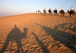
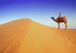
The North West area of state is dry and sandy and encompasses the Thar Desert. Some portion of this desert extends into Pakistan. Moisture laden South West Monsoon winds are not intercepted by Aravalli Range. These winds move towards Arabian Sea. The reason behind letting these winds go uninterrupted is position of Aravalli Range. Thus, rest of the North West region will be left as rain shadow. The population close to That Desert is quite low and the largest desert city in this state is Bikaner. Close to this area, scrub forests can be seen. Less than 400 mm rain is received by this region on an average. Sometimes, the temperature escalates beyond 45 degree during summers and in winters, it falls beyond freezing point. In forest zone characterized by thorn scrub, Marwar, Godwar and Shekhawati region lies. The main river flowing through Godwar and Marwar regions is River Luni. It drains Aravallis western slopes emptying into Runn of Kutch located in Gujarat. Water of this river is potable only till Barmer district and the remaining water is saline. River Ghaggar originating from Haryana flows feebly and later disappears into Thar Desert and its sand dunes. It is considered to be erstwhile Saraswati River.
Fertile land can be seen to the east of Aravalli Range. This is because, this region is better watered. Dry deciduous forests of Kathiarbar-Gir region can be seen in this region. Hare forests have broadleaf and encompasses trees like Acacia and teak. In Southern Rajasthan, Vagad region is located which is quite hilly and is close to Gujarat border. Vagad is considered to be wettest region of this state with Mount Abu as an exception.
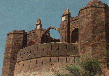
Mewar region is located in the northern part of Vagad. Main cities of this region are Chittaurgarh and Udaipur. In the South West, Hadoti region is situated sharing border with Indian state, Madhya Pradesh. Dhundhar region is located close to Mewar where Jaipur is the main city. On the eastern fringe of this state, Mewat is located that shares its border with Uttar Pradesh and Haryana. South East and East Rajasthan is divided by Chambal and Banas rivers.
Area
The largest state in India, Rajasthan is located in North West of the country. It is sprawled in 3, 42, 239 sq km area and comprises of 11 percent of the total area of India. Shaped as rhomboid, the length of this state from west to east is 869 km and from north to south, it is 826 km.
Topography
Diverse topographic features can be seen in this state, though the bulk area is dry and arid. Huge mountains of sand dunes, rocky terrain, barren tracts, wetlands, river drained plains, wooded regions, ravines and plateaus are some of the topographical features witnessed in Rajasthan. Topography can be divided as under- Thar along with dry regions, Aravalli with other Hilly regions, fertile plains, plateaus like Malwa and Vindhya and water bodies that include salt lakes and rivers.
Soil & Vegetation
With this diverse topography, the vegetation and soil of Rajasthan also gets altered. Another factor responsible is water availability. Different types of soils found in this state are saline, sandy, chalky, loamy, alkaline, clay, nitrogenous soils and black lava soil. Since rainfall in this region is quite limited, seasonal vegetation in the form of shrubs, grass species and dwarf trees can only be found. In plains, food crops are grown in areas where streamlets and rivers drain enough water for irrigation. Thus, deposits of clay soil and alluvial soil enhance land fertility. Aravalli and other hilly tracts are characterized by lava soils that help in producing sugarcane and cotton.
Rajasthan Desert
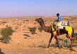
70 percent of the state’s total landmass has been occupied by the Great Indian Desert, also referred to as the Thar Desert. It is the largest desert of the country and its major portion is found in this state. Districts like Barmer, Jaisalmer, Jodhpur and Bikaner are desert cities. Three cities namely Bikaner, Jaisalmer and Jodhpur forms the famous Desert Triangle. During summers, the temperature in this area reaches crescendo and in winters, the temperature drops significantly. Less than 25 cm rainfall is experienced on an average annually. Shrubs, thorny plants and xerophilious grass can be spotted. Snakes and lizards in diverse species are seen.
Flora & Fauna
Wide range of flora and fauna peculiar to this arid region can be seen. They have adapted such so as to survive waterless, dry and arid region found in this state. Deciduous forests are the major forest vegetation seen in this state. It encompasses grasses, thorny trees and shrubs. Bamboo, teak, khejri and acacia are the main species. Plants and herbs with immense medicinal value are also found. As far as fauna is concerned, 25 serpent species, 25 lizard species, etc can be spotted. Russel Viper and Spiny Tail Lizards are the most common reptiles. Indian Gazellas, Antelopes, Black Buck, Indian Bustard, Nilgai, silver fox, wild cats, etc are some other wild life species seen in this state. 450 avifauna species can also be seen here.
Weather
Rajasthan experiences varying climate just like diverse topography. Four different seasons are experienced by this state- Pre monsoon, Monsoon, post monsoon and winter. As the name suggests, pre monsoon is the time just before monsoon arrives. During this time, temperatures are high. This season begins from April and continues till June. Monsoon season starts in June and continues till mid-July. From mid-September till late November, post Monsoon continues and winters occur between December and March.
Related Image

Also Browse Following Under This Section
Related Topics
Chokhi Dhani
The Chauki Dhani Village has an ethnic village which has over hundred cottages and haveli suites apart from the multi....
Best Time To Visit Rajasthan
Rajasthan is well renowned as "Land of Kings". The literal meaning of its name also depicts the same thing. As far ....
About Rajasthan
In terms of area, Rajasthan is one of the largest ...