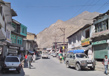
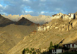
Kargil
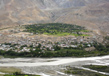
Kargil is a wide river basin with broad terraces that are alienated from Mulbekh valley by a 12 km long Wakha gorge. The land, which is accessible along the tapered valley, is cultivated intensively with terraces where people grow wheat, peas, barley, variety of vegetables and other cereals.
Kargil is well known for its fine apricots. In May, the complete countryside becomes fragrant with the blossoming of beautiful white apricot. August sets the ripening of fruits, which lends an orange hue to the surroundings. Kargil once served as an important trading and transit centre on two routes from Srinagar to Leh and to Gilgit and the lower Indus Valley.
After Leh, it is the second largest town in Ladakh district. It is located 60 km and 204 km from Drass and Srinagar respectively.
People inhabiting Kargil are of mixed Dard and Tibetan descent. The people of Kargil were believer of Tibetan Buddhism until 14th-15th centuries. Thereafter, Muslim missionaries began to proselytise the local people. Composition of inhabitants today consist of 90% Shia Muslim, 5% Sunni and 5% Tibetan Buddhist.
Earlier, Kargil was a transit point of caravans carrying exotic merchandise of silk, brocade, carpets, felts, tea, poppy and ivory to and from China, Tibet, Yarken and Kashmir till 1949. Since 1974, with the arrival of tourists in this region, it has been marked as centre for tourism related activities.
The mosques of Kargil speak a lot about the changes this city has witnessed down the lane of history. The older mosques in Kargil reveal Tibetan and Iranian styles of architecture, whereas comparatively new mosques portray modern Iranian and Arabic influence.
Geography
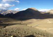
Kargil lies on the banks of River Suru (Indus) which flows at a height of around 10,000 ft. and has an average elevation of 2,676 metres (8,780 feet). Nestled in the lap of Himalayas, Kargil has moderate weather just like the other locations in this region. During summers, days are hot with cool nights. However, winters last for months and temperatures often dip to −48 °C.
Zanskar Plateau here is even colder. It is a near-uninhabitable place for humans, except for the hardy Khampas who are used to living among these harsh conditions. The entire Kargil district is spread over 14,086 sq. km.
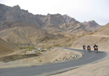
National Highway 1D connecting Srinagar to Leh passes through Kargil. This highway is open for vehicles only from June to mid-November due to heavy snowfall at Zoji La pass in the remaining months.
History
In ancient time, the major part of present Kargil was named as Purik that comprised of small but independent areas. Some of these included Chiktan, Phokhar, Sot and Suru Valley. The rulers in these areas would often fight against one another over insignificant issues. An exiled prince named Gasho Thatha Khan from 9th century AD was the first to have got all these territories together under one administration.
Another ruler named Purik Sultan area also fought and increased his area to include areas named Zanskar, Pashkum and Sodh that make up present day Kargil district. He made a place named Karpokhar his capital.
Places of Tourist Interest
Kargil primarily serves as an excellent base station for adventure activities such as mountaineering, trekking, river rafting and camping. The mountaineers who attempt to climb Nun and Kun, both over 7000 m high, start from here. It is also the base for short excursions to Mulbek where the main attraction is a high rock 9 m sculpture portraying the future Buddha.
Kargil also presents some exciting walking paths all along a river bank and next to a hillside. The finest among these is a road that takes one to Goma Kargil along a 2-km long zigzag road that passes through some of the most picturesque parts of Kargil’s countryside. It presents a breathtaking view of mountainous streams. The town has an atmosphere pertaining to medieval times with narrow cobbled streets.
A leisurely walk in the market might guide tourists to a shop which sells tobacco pouches, flint and brass kettles along with travelling hookahs and handcrafted items. These items make great souvenirs to carry back home. However, for the people of Ladakh, they are daily use items.
Most shops sells common consumer goods with some specialized in trekking provisions. The Government Industries Centre showroom displays and sells the much talked about local carpets, Pashmina Shawls and other woolen handicrafts. A rare delicacy is the apricot jam which is produced here. Kargil's dry apricot is now counted among the ‘must carry home’ items, which is freely available in the local market.
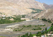
Suru Valley
In summer, when the land garlands itself with colourful blooms of wild flower, the landscape of Suru Valley is worth watching. This valley extends right from Kargil town to Penzi La watershed. This is also the place where Suru River originates. A majority of the population here consists of Tibetan-Dard Muslims. These people were converted to Islam during 15th century. There is the Nun (7,135m) and Kun (7,035m) peaks here, which enhance the beauty of this region and make its popular tourist destination.
Kartse Khar
This is an ancient village in the Kargil region, known famously for a 7m high rock engraved statue. This statue of Maitriya Buddha is a trustworthy proof of the fact that Buddhist community existed in this valley even in ancient past. In fact, the area has many other brilliant Stupas and rock carved statues that speak of the Buddhist influence. They are a must visit for inquisitive and adventurous tourists.
Panikhar
One of the best places to start your mountaineering expedition to the peaks adjacent to Kargil valley is Panikhar. Tanyol is the advance base for those who want to trek to Mt. Nun. From here a short walk through the hill slope takes one to Sentik Ridge. This works as the base camp for the ice plateau. One can also take a hike to Nun- Kun view saddle, which also lies on Parkachik Ridge. This is a 3-hour walk along lush green slopes and one gets to enjoy excellent views of mountains and the valley below.
Drass
Drass is located at an hour’s distance from Kargil. Considered one of the coldest places that are inhabited in the world, Drass is surrounded by beautiful pastures and magnificent mountain peaks. Temperature here dip to as low as -50oC in winter.
Though now is dominated by Muslims, this place once upon a time believed to be predominantly a Buddhist region. The only Buddhist remains now comprise a noteworthy stone of Maitriya, Avaloketeshvara, a lotus flower, a man on horseback and a stupa.
The cultural make up Drass is particularly interesting. It is occupied by the Dards stock, which is an Aryan race. It is believed that people of this race came from Central Asian steppes. They initially travelled to the villages around Kargil and settled in areas of western Himalaya. They speak Shina language.
Polo is a favourite sport among inhabitants of Drass. Because of Pakistan’s misadventure in Tiger Hill and Tololing areas, Drass has become well known in recent years. One may enjoy a wonderful view of Tiger hill from Drass village.
How to Reach
By Air
The nearest airport is at Leh and one can drive down to Drass from here. However, this airport is at a high altitude. Therefore, those with heart trouble or lungs problem should take precaution and must take check with a doctor before flying to such a high altitude.
By Rail
The nearest railway station is located at Jammu, which is about 739 km from Leh.
By Road
Kargil is situated about 204 km from Srinagar and 234 km from Leh. All Tourists travelling from Srinagar to Ladakh by road are required to register themselves at the Tourist Registration Centre at Drass.
Related Image
Also Browse Following Under This Section
Related Topics
Cities and Destinations
Jammu and Kashmir stand as an famous tourist destination based in the northern part of India. People are passionate....
Cuisines
The Indian state Jammu and Kashmir is not only considered as a paradise for its travelers but also for its food lovers....
Gulmarg Trekking
Trekking is one of the most famous and...
Sonamarg Trekking
In Jammu and Kashmir, Trekking is the...