Being the easternmost tributary of Indus, the river originates in Rakshasthal Lake in Tibet. Flowing northwest for 260 kilometers it reaches the Shipki La pass while entering Himachal Pradesh. Taking a turn west-southwards, it runs another 360 kilometers to meet the Beas near Makhu of Firozpur district in Punjab State. Thereafter, it continues west-southwards and enters Pakistan for 15 kilometers east of Kasur District in the Fortier Punjab Province. 17 kilometers more and the waters of Sutlej unite with the Chenab while forming the Panjnad River before becoming a part of the mighty Indus, 100 kilometers from Bahawalpur.
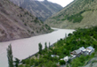
The hydrology of Sutlej River is vastly controlled by glacial waters as a result of melting snow in the Himalayas along with the South Asian monsoons. During monsoons, the waters of Sutlej overflows and the maximum flood discharge recorded in 1955 was 600,000 cubic feet (approx 17,000 cubic meters) per second. Flow in winters is substantially reduced with the lack of both monsoons and glacial melt.
History and Etymology
The upper part of the Sutlej Valley was once called the Garuda Valley by Zhangzhung, one of the first civilizations in ancient western Tibet. Then, Garuda Valley was the epicenter of a vast empire that stretched several miles across the Himalayas. The valley also has reminiscent of the Kyunglung, a towering palace build during the Zhangzhung civilization in upper Sutlej Valley. The ruins still exist and have been found in the present day Moincer Village, located southwest to the Mount Ti-se or what is better known as Mount Kailash. Eventually, the Zhangzhung civilization was captured and taken up to become the Tibetan Empire.
The Sutlej Valley still has some nomadic villages of yak herders and is the original descendants of the Zhangzhung civilization. In those times, the Sutlej course was the main mode of transportation for trades and kings. In the early 18th century, the river was widely used to transport Deodar wood to Hamirpur District, Bilaspur District and other places along the banks of Sutlej.
Sutlej River along with other rivers running through Punjab is believed to have drained into the Ganges before 5 mya. Substantial geological evidence have been gathered that necessarily point out that the river was present much before 1700 BC and that it was one of the main tributaries of the legendary Ghaggar-Hakra River or the Sarasvati. It was the tectonic activities and the change of plates that redirected Sutlej more towards southwest. This diversion had occurred nearly 4000 years ago and may have been the reason for Saraswati drying up. However, there is clear evidence that Sutlej may already have been captured by Indus waters thousands years ago.
There are also evidences that Sutlej has been responsible for the local faulting along Rampur area. This is similar to the activity in the Nanga Parbat region by River Indus but on a much smaller scale. Sutlej River exhibits a doubly inverted metamorphic gradient.
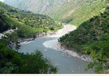
Course
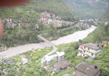
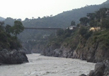
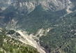
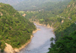
The Sutlej River rises in the northern slopes of the majestic Himalayas from Lake La’nga, in Southwestern Tibet, from an elevation of over 15,000 feet (approx. 4,600 meters). Initially flowing northwards and then changing its course west-southwards along the Himalayan gorges, Sutlej River crosses the Indian State of Himachal Pradesh before entering into the main territory in Punjab plains close to Nangal. Thereafter, the river continues its southwards course in a broad channel while receiving Beas River and forming a total length of 65 miles (approx 105 kilometers) at the India – Pakistan border before entering Pakistan. In Pakistan, it runs its course for another 220 miles (approx 350 kilometers) before joining the Chenab River located west of the Bahawalpur Region. The combined flow then forms the final Panjnad, the link between the Indus River and the Five Rivers.
Tributaries
Baspa River
This River rises in Indo Tibetan border and forms the Baspa Valley – one of the best scenic spots along the Himalayas. The river starts in the Baspa Hills and joins Sutlej River near the left bank of Karcham.
Spiti River
The Spiti River originates from Kunzum Range and Kabzian / Tegpo streams. It meets Sutlej at Namgai near Kinnaur District after flowing for a total length of 150 kilometers.
Soan River
Rising from the slopes of the Solasinghi or Shivalik Range and joins Sutlej east of Beas in Kangra Valley.
Nogli Khad
The Nogli Khad meets the Sutlej just after the Rampur Bushahar along with other tributaries like Bahlu, Siman, Siun, Mandi, Khadel, Bhagmati and Bantrehr.
Related Image
Also Browse Following Under This Section
Related Topics
Culture in Punjab
The word "Punjab" is composed of two Persian words, 'Panj' meaning five and 'Aab' which means water. The invigorating ....
Rivers
The Punjab has an area of19500 square miles (50365sq.kms) with a population of about 24, 00,000 in 2000. Punjab is a land ....
Fairs & Festivals
Punjabi's are great fun-filled and love ...