The Chenab is a major river in Jammu and Kashmir, India and in the erstwhile Punjab Province in Pakistan. It is formed in the upper Himalayas and flows through the Jammu plains to finally drain into the Punjab Basin. Its total course is approximately 960 kilometers. The Chenab River has been in the news for the various hydroelectric projects build on its course by the Indian Government and most notably the Bagihar Hydro electric power project. The Chenab waters have always been contested for by both India and Pakistan and several disputes and collaborations have been arrived as a result.
History and Etymology
It is said that Chenab has the same position in the consciousness of locals as Rhine is important for the Germans or as an instance Danube for the Austrians. The Chenab has been an iconic river in the ancient Indian civilizations and reference could be drawn in the epic tale of Heer Ranjha along with the legend of Sohni Mahiwal. The river has been an important part of Indian civilization since the Vedic period when it was solely known as Chandrabhaga and sometimes as Iskmati and Ashkini. The ancient Greeks referred the Chenab as Acesines. It is believed that Alexander- the Great established the town of Alexandria at the confluence of Indus and Ravi Rivers. The site is presently popular as Uch Sharif and Mithankotor Chacharan at Pakistan.
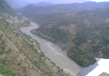
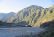
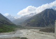
As previously noted two streams by the name of Chandra and Bhaga separately rise on the Bara Lacha pass at an elevation of 4891 meters in the Himalayan ranges and finally meet downstream at Tandi to become the Chenab at an elevation of 2286 meters above sea level. Thereafter it enters the Chamba district at Bhujind and passes through Sansari Nala to meet the Podar Valley at Kashmir. In the Himachal alone, the Chenab flows for a total of 122 kilometers. The catchment area of the river is 61,000 sq. kilometers out of which over 7,500 sq kilometers lie in Himachal Pradesh. In terms of water volume, it is the largest river in Himachal Pradesh. The Chenab Valley has a structural trough formed between the Pir Panjal and Himalayan Ranges.
Course
Chenab River is one of the five important rivers that form the Indus Valley. The waters of Chenab are mainly fed by snow melts from the Bara Lacha pass located at Himachal Pradesh. The waters of this river that flows south are popular as the Chandra River flow and those running north are called the Bhaga waters. Eventually, Bhaga River takes a turn to the south and along the village of Tandi joins Chandra River to form Chandrabhaga or Chenab. There is a motorable road running along Bhaga River from Khokhsar till Tandi. The river eventually becomes the complete Chenab after passing through Marau River near Bhandera located at a distance of 12 kilometers from the Kistwar town in Jammu and Kashmir.
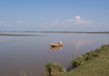
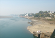
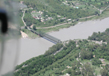
Thereafter, Chenab flows downstream from the Jammu and Kashmir plains and drains itself into the Punjab plains and thereby forming the boundary between Jech and Rechna interfluves at Pakistan (The Doabs). The course is joined by Jhelum River near Trimmu and thereafter by the Ravi River near Ahmedpur Sial. Thereafter, the water merges with Sutlej at Uch Sharif to form the Five Rivers or Panjnad. The fifth river is Beas that joins Sutlej near Firozpur district in India.
Tributaries
Bhaga River
Bhaga River originates itself in the Lahual Valley and if fed by a number of glaciers, before joining Chandra stream in Tandi. From its origin, this tributary forms raging torrents forming U-shaped valleys, moraines, glaciers and waterfalls in the upper catchment area. The entire course is devoid of any substantial vegetation. In the summer months, Bhaga River is at its bulging best.
Chandra River
Chandra river rises from the snow fed basins in the Lahual-Spiti district. Flowing for a considerable distance in the south east direction, it takes a 180 degree turn to move south west. The entire region is a cold desert receiving negligible rain. An important settlement along its course is the Koskar village.
The Miyar Nala
This tributary rises in the Himalayas near Lopen and travels 35 kilometers to join Chenab at the right bank of Udaipur.
The Marusudar
This is the biggest right bank tributary of Chenab, originating from an elevation of 5175 m in a fan shaped catchment.
The Ans
Ans is fed by two streams and finally meets Chenab at its right bank at Salal H.E. Project.
The Tawi River
A major left bank tributary of Chenab, Tawi River originates from Udhampur district in the Himalayas and joins Chenab at the international border between India and Pakistan. Its total length is 144 kilometers.
Related Image
Also Browse Following Under This Section
Related Topics
Culture in Punjab
The word "Punjab" is composed of two Persian words, 'Panj' meaning five and 'Aab' which means water. The invigorating ....
Rivers
The Punjab has an area of19500 square miles (50365sq.kms) with a population of about 24, 00,000 in 2000. Punjab is a land ....
Fairs & Festivals
Punjabi's are great fun-filled and love ...