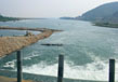
Pennar River
Pennar River is based in southern India and it is located in the Chikballapur district of the Karnataka state. The Pennar River is also known as the “Uttara Pinakini”. From Karnataka, the river runs from the state of Andhra Pradesh and empties into the Bay of Bengal. The river approximately is 597 kilometers long and it occupies about the 55,213 kilometer area. The maximum area of the river basin is spread in the state of Karnataka and Andhra Pradesh and lies in the shadow region of the Eastern Ghats.
Course
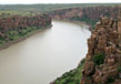
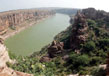
Pennar River originates from the place called as Nandi hills, rises from the Chenna Kesava Hills which is located in the Nandi ranges, Mysore in the state of Karnataka.
The river travels almost 40 kms in Mysore and then, it travels through the Anantapur district, followed by the Cuddapah and then Nellore. Then, the river enters the Bay of Bengal from Utukur through many channels. Only in the state of Andhra Pradesh, the river crosses more than 568 kms.
The average water source of the river is approximately 6320 and the total live storage capacity of projects under construction is 440 and total live storage capacity of projects is 3249. The river has one flood forecasting system station. The basin of the river is formed by some of the Archean rocks which are principally intrusive metamorphic schist. The basin is also full of different and important soil types like red soil, sandy soil, black soil and mixed soil. The basin has a very less cultural area.
Tributaries
There are many principal tributaries of Pennar and they are Jayamangal, Papagni, Chevveru, Kunder, Chitravati and the Sagileru. The left side have Jayamangali, Kunderu and Sagileru river as tributaries. On the right of the river there are Chitravati, Cheyyery and Papagni. The water area of the river along with its tributaries covers the southern Deccan plateau. The watershed of the river is formed by the Kolar plateau and those of the Kaveri, Ponnaiyar and Palar.
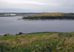
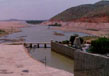
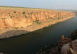
Reservoir
The Pennar River has two major reservoirs called as the Somasil Reservoir and the Sathanur Reservoir. The Sathanur dam was made in 1958 and is located near the Chennakeshava hills in Chengam. Somasila is one of the major projects that have been developed on the Pennar River. The dam is located near the Atmakur Taluka in Nellore. The dam has helped complete major projects and the nearby villages can rely on the dam for irrigation and water supply. Out of the two reservoirs the Pennar River has, Sathanur was developed in 1957 in the Tiruvannamalai district and has the total capacity of 228.91 million and it serves the nearby areas for irrigation and drinking water.
General Information
The river is surrounded by the Erramal range to the north and the Nallama on the east. The Veikonda is present in the Eastern Ghats and the Nandidurga hills can be seen on the south and on the west sides the narrows bridges that separate the Vedavati valley and the Krishna basin. There are many under construction and completed projects that have been undertaken and the only major project that is in the basin of the river is the Somasila Project. Nellore is the most important town which is located in the basin of the river. The basin has a very low scope of industrial development due to some limitations. The basin consists of very limited sources of power and minerals and that is why there are no major industries in Nellore. The basin consists of small industries that are based on the agriculture. These small industries are cotton weaving, sugar mills, paints, glass, ceramics, matches, soaps, tobacco, varnishes, rice mills and oil mills. The basin of the river has a dry tropical climate and the basin can have temperature up to 25 to 46 degrees in summer. In winter, the temperature can range between 18 to 28 degrees. The rainfall is experienced between June to September. The rain shadow area of the basin does not allow the moisture to reach the basin. The basin has experienced a major drought in the year 1990. This was the worst year and causes misery among the farmers who are dependent on the rainfall. After that there were political demands to create an adequate amount of water supply in the region.
Related Image
Also Browse Following Under This Section
Rivers
Related Topics
agara-lake
The agara-lake is a famous artificial lake which has its location 20 km away from the Hyderabad city in the....
Ntr Gardens
ayyanakere-lake is a very famous delta that is situated in the Andhra Pradesh in district of East Godavari. Water has surroun....
Shamirpet Lake
Shamirpet Lake is a man made or artific...