Ghataprabha River
The Ghataprabha River is one of the important rivers in South India. It flows east for around 283 km and meets Krishna River at Almatti. It is an important right-bank tributary of the Krishna River. The river basin stretches to around 8,829 km wide across the states of Karnataka and Maharashtra.
Course
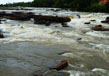
Originating in the Western Ghats near Chaukul village in the Sindhudurg district in Maharashtra state, Ghataprabha River arises 12 kms away from Amboli, a popular hill station. It thus forms the east face of the hills from where the river Hiranyakesh originates, one of the main tributaries of Ghataprabha River. Then, the river flows east and into Kolhapur where it forms a lake called Phatakwadi. A dam is built at the river here as per the Maharashtra jurisdiction and there is also a hydroelectric plant on this dam. It generates around 13 MW power. The river ends its course near Daddi town, located in the Belgaum district and here the river Tamiraparani joins it.
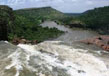
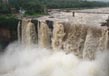
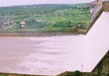
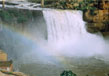
The river forms a natural boundary between Karnataka and Maharashtra beyond Daddi. The river then is collected at the Hidkal reservoir which is the source of irrigable water to the area. There are man-made canals that drive the water of the river into the fields. The river by now is just an overflow from the Hidkal dam. From thereon, the joining of Hiranyakesh River strengthens it and thereby flows through sandstone hills. It then clashes over a cliff at 53 km high and forms the famous Gokak Falls. Here the Markandaya River joins the Ghataprabha River. From thereon, Ghataprabha River meanders through a north-easterly course flowing towards Mudhol town and taking a south-easterly turn, reaches Bagalkot. Here, it widens out and flows on to merge with Almati dam on Krishna river.
Tributaries
Hiranyakesh River and Markandeya River are the two main tributaries of Ghataprabha.
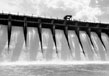
Ghataprabha Reservoir
A reservoir has been built across the Ghataprabha River to store and provide water for irrigation to the surrounding areas. The reservoir is around 53.34 metres in height and 10183 km long. The work started in 1897 and a long canal around 71 km in length was created from Dupdal weir on the river near Gokak canal. The second stage of the reservoir extended from Dupdal weir to Ghataprabha River near Hidkal, at a height of 650.14 meter and with a length of 109 km.
The Ghataprabha reservoir now stores around 659 Mcum water and irrigates around 1.396 hectares of land. The third stage of the reservoir raises the dam to its final level of 2175 feet and can store around 1448 Mcum of water. This water when channeled through two canals, 202 km long and 86 km long respectively, can irrigate around 191386 hectares of land, thus irrigating a total of 3.31 hectares of land.
Related Image
Also Browse Following Under This Section
Rivers
Related Topics
agara-lake
The agara-lake is a famous artificial lake which has its location 20 km away from the Hyderabad city in the....
Ntr Gardens
ayyanakere-lake is a very famous delta that is situated in the Andhra Pradesh in district of East Godavari. Water has surroun....
Shamirpet Lake
Shamirpet Lake is a man made or artific...